The popularity and affordability of Unmanned Aerial Vehicles (UAVs) has benefited many industries by reducing costs and increasing personnel safety. But what about the scientific community? Hundreds, if not thousands, of independent scientists and universities around the world use these UAVs to conduct complex scientific experiments in new ways.
We tend to focus on the industrial and commercial applications of UAVs, but pure science also benefits from the affordability and availability of aviation when budgets are tight and time to complete experiments is critical.
For example, several Polish scientists collaborated on a comprehensive study of coastal erosion, using several new technologies such as airborne LiDAR and bathymetry.
Pawel Tysiac and Rafal Ossowski of the Faculty of Civil and Environmental Engineering at the Gdansk University of Technology, in collaboration with Lukasz Janowski of the Maritime Academy of the Maritime University of Gdynia and Damian Moskalewicz of the Department of Geomorphology and Quaternary Geology at the Faculty of Oceanography and Geography of the University of Gdansk, have culminated in a comprehensive study of the erosion of a portion of the Polish coast (more More specifically, a 1-mile stretch of the southern Baltic Sea).
The paper is entitled "Assessment of coastal cliff degradation using drone and orthophoto data and bathymetric LiDAR in Google Earth Engine". It was published in Scientific Reports, January 2025 and is a prime example of the use of new technologies to collect data that is critical to understanding the ways in which nature changes geography.
We had the opportunity to speak with Pawel Tysiac, one of the study's authors, to better understand the impact of drones and LiDAR on their project.
"Traditional methods of monitoring cliff erosion typically require labor-intensive field work and complex calculations of spatial point distributions using traditional land surveying techniques," said Pawel. "In contrast, recent advances in remote sensing and machine learning offer new methods for assessing cliff degradation with greater efficiency and accuracy."
Coastal degradation has attracted the attention of governments and scientists around the world as the number of natural disasters increases and each disaster causes more and more damage to populations and geographic environments.
"In this paper, we use the term 'bluff degradation' broadly. We define it as the overall ultimate impact of changes in erosive coastal cliffs caused by a variety of factors and processes, including complex lithologic and hydrogeologic environments, storm surge wave activity, rainfall, wind blowing, and human activities that lead to the development of large-scale movements and their impacts, such as landslides, faults, fissures, and debris," Pawel said. "Based on this, a key premise of this study is that the electromagnetic wave reflectance spectrum varies in areas affected by degradation. In the case of coastal bluffs, changes in material aggregation, vegetation and other factors can lead to significant differences."
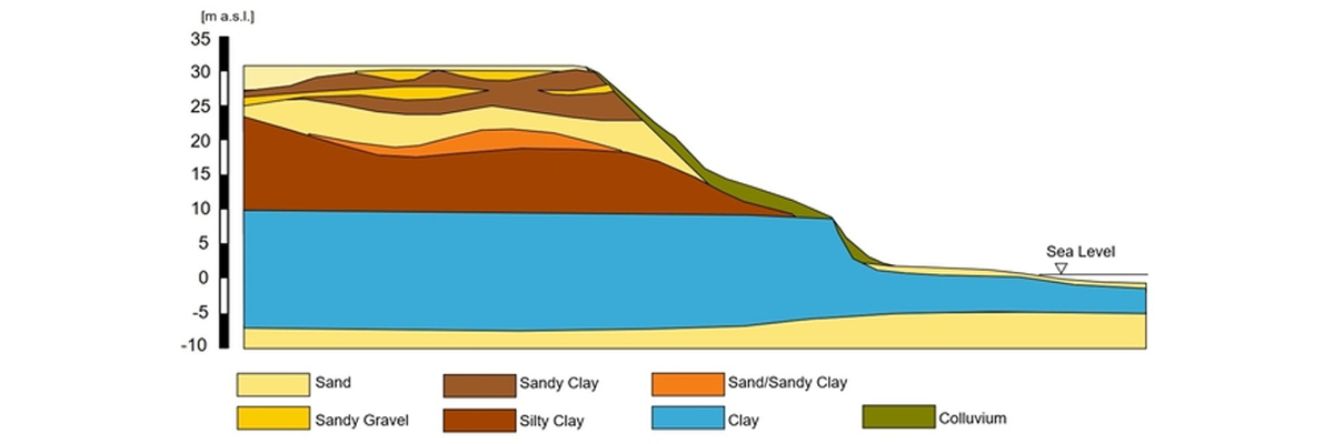
Today, remote sensing is the standard method for monitoring coastal environments. By utilizing various types of images and data collected from satellites, airborne platforms, and ground-based sensors, researchers can obtain detailed and up-to-date spatial information about coastal areas. Timely resolution frame images allow observation of changes in coastal morphology over time and help to identify areas most affected by natural disasters. In this case, the authors used aerial photography, which provides high-resolution images useful for detailed before-and-after comparisons. However, there is the problem of different times of illumination on the images, leading to different objects to be processed. In terms of photogrammetry, flights need to be conducted under similar conditions, but there are still some issues with seasonal variations in this regard.
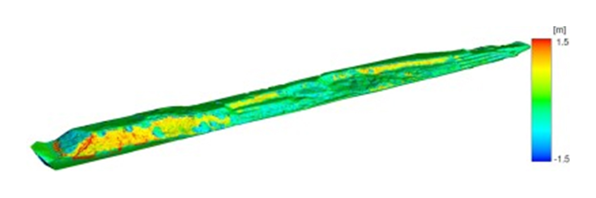
"We decided to use LiDAR as an alternative to deal with changing lighting conditions," says Pawel. "LiDAR data is essential for measuring coastal topographic changes with high accuracy, helping to filter data from vegetation or isolated points. The most important product of LiDAR is the Digital Elevation Model (DEM), which is used to create a 3D representation of the coastal landscape. These models help to understand the spatial distribution of erosion by calculating models over time."
The problem arose because the component of coastal degradation that occurs underwater plays a significant role in causing this phenomenon to occur, hence the decision to use LiDAR as a bathymetric tool.
Pawel said, "The results of the study give us insight into how coastal cliffs are responding to current and future climate change, particularly sea level rise and increased storm activity." "Enhancing traditional geotechnical surveys by utilizing proposed advanced remote sensing technologies, such as the use of drones and airborne surveys, provides a model for other areas facing similar challenges. The insights gained from this study can inform coastal management policies not only in Poland, but also in other regions with similar geological and environmental conditions. Effective management plans based on such research can help mitigate the risks to human life and infrastructure posed by coastal cliff erosion and instability."
By combining aerial and maritime information collection from autonomous vehicles, this group of scientists was able to improve the quality of the data, the precision of the conclusions, and the adequacy of the actions taken to mitigate the damage to the geography and inhabitants of the affected areas.
Post time: Feb-12-2025